To access La Grave from Grenoble or Briançon by bus, click to the following link : access to La Grave.
and the new ligne 6 : ligne-6-ete-2024-la-grave-briancon
SUMMER
Access by foot only. It is forbidden to take the track by car. Please respect this for the confort of all the hikers !
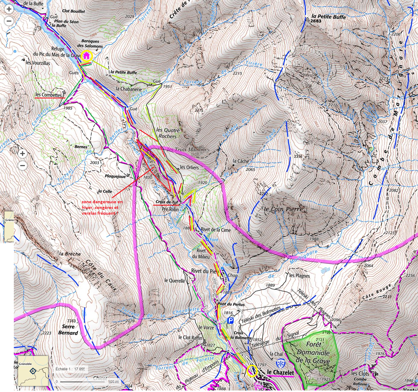
MAIN ACCESS BY THE TRACK (in yellow on the map)
About 1h30 from the Chazelet – 5.5km – vertical +250m.
This is the most direct but not the prettiest route, the track being used by shepherds, farmers or us from time to time (supplies).
Park in the parking of the Plateau d’Emparis, at the bottom of the village of the Chazelet. Be careful not to drive through the village, bypass it by the right road at the entrance.
At the very bottom of the village begins a track. Take this track and follow the directions. You will cross the hamlets of the rivets, then arrive at a bend called “The Cross of Tuf” because of a large stone cross . You are halfway. Follow the main track that dominates the river (the Gâ). The refuge will be on your right when you pass the small stream (or large depending on the season!) of the Courbeille.
OTHER EASY ACCESS – TRACK N°5 of the “CHEMINS D’AVANT” (=trails about before)
About 1h45 from the Chazelet – 6km – vertical +250m.
You can access the refuge by two other paths more friendly than the main track and not much longer! These two paths allow you to make a loop, with the refuge in the middle.
Left bank of the Gâ: by “Les Orliers” (in light green on the map).
Follow the main track to the Tuf Cross (as shown above). At this crossroads, take right towards “Les Orliers”. Follow a good trail that will take you to the Orlier’s sheephouse, then to the Chabanerie, and continue to a large cairn (=pile of stones). At the cairn take left and go down the path that leads you to the refuge.
Right bank of the Gâ: by “Les Combettes” (dark green on the map).
From the Chazelet, take the main track only a few minutes to the village mill. At the crossroads, follow the “Les Combettes” sign. The track climbs into laces and then becomes flat. Just before arriving at the (private) house of Les Combettes, take on your right a path that descends frankly towards the torrent. Cross it through the footbridge, take left on the main track and walk 2 minutes before seeing the refuge on your right.
OTHERS ACCESS
– from BESSE or Mizoën
Join the “Plateau d’Emparis” by road or with the GR54. Take the Rif Tor valley and walk down to “La Grande Buffe” house located at the foot of the Pic du Mas de la Grave. Take the good path from there the refuge that will be on your left.
About 2h30 from the “Col Saint-Georges” ; 3h from the chalet du Fay/refuge des Mouterres
– with GR54 (Tour de l’Oisans)
On the “plateau d’Emparis”, at the Souchet pass, join the “Brèche” by a small path marked in red (section of the No. 11 of the “chemins d’avant”). At the breach (“Brèche”), walk down into the valley of the Buffe towards the track of the Combettes. Once the big trail has been found, follow it (towards the Pic du Mas) to a crossing located 100 meters before the house of the Combettes. Take a smaller path that goes down to the torrent. Cross it through the footbridge, take left on the main track and walk 2 minutes before seeing the refuge on your right.
NOTE: The refuge du Pic du Mas de la Grave is located on the paths 5, 10, 15 et 20 of the guide “Chemins d’avant” : http://cheminsdavant.com/
WINTER
PRINCIPAL ACCESS by the RIVETS – Les ORLIERS – bottom of the valley (black on the map)
About 1h15 ski touring / 1h30-2h snowshoeing
The beginning of the path is the same as during the summer: follow the main track that starts from the bottom of the village of Le Chazelet to the turn of the Cross of Tuf, passing through the 3 hamlets of the Rivets.
From the Tuf Cross, we advise you to take right at the crossroads, climb up to “Les Orliers” sheepfold, continue straight to the mountainside for a few hundred meters, then descend to the Gâ torrent and follow it along the valley to the refuge. Because the summer road can be very tricky and icy at some points !

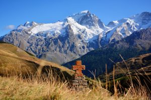
The Cross made of Tuf